Saddleback and the Santa Ana Mountains got an amazing amount of snow yesterday, and I went out to a couple of spots this morning to take photos. Check this Flickr set for more.
Saddleback and the Santa Ana Mountains got an amazing amount of snow yesterday, and I went out to a couple of spots this morning to take photos. Check this Flickr set for more.
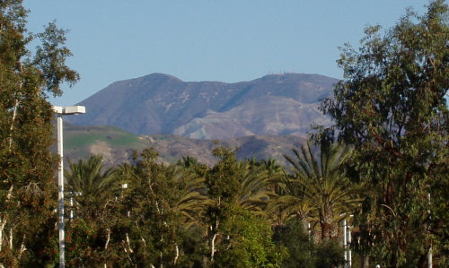
Back in October, shortly before the Santiago Fire, I went sightseeing in the Tustin Foothills and snapped a picture of Peters Canyon, the hills behind it, and Saddleback in the background. A month later, I took a picture of the same view after the fire and posted the two as a before and after comparison.
Well, we’ve had several months of normal (for SoCal) rain, and the hills have turned green. Mostly. It’s clear that the scars from the fire are going to take at least another season to heal. The last couple of days have been very clear, so I went back to the same spot to take a “four months later” photo.
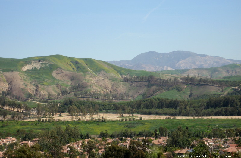
March 10, 2008. Click for a larger version
Now compare it to the November (post-fire) and October (pre-fire) photos: Continue reading
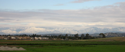
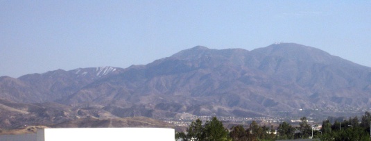
We went to The District on Saturday afternoon to catch Cloverfield and check out the Auld Dubliner. I took the Warner exit to go in the back way, and noticed someone standing out on the shoulder of the ramp, taking photos. I looked out past the wide expanse of empty fields and was astonished to see the entire San Gabriel mountain range covered with snow!
Not just the tops of the mountains on the eastern half of the range, but everything, even the lower parts you can just barely see by the Cajon pass, and this huge expanse north of Los Angeles that I’m not sure I’ve ever seen covered.
I pulled over as soon as I found a spot I considered safe, then walked back up to the top of the ramp. I talked briefly with the man I’d seen taking photos, and he said he’d lived in the area for 50 years and had never seen the mountains like this. He also mentioned he had a friend who had served at the base*, and he was going to send him the pictures.
I ended up taking a 12-photo panorama (zoomed) spanning at least 120° from the blimp hangar on the left, across the San Gabriels, past the hills above Orange and Tustin, the foothills of the Santa Ana Mountains, on to Saddleback, which had a few bits of snow clinging to the mountainside.
![]()
Click to view panorama (424 KB 6648×500 JPEG)
*This is the location of the former MCAS Tustin. The Marine base was closed in the mid-1990s, and the land is only just starting to be developed—notably The District in one corner, which is what brought us to the area yesterday.
Update December 18, 2008: This post is getting a lot of traffic today, but it’s from last winter. If you want to see photos from this week’s snow, check out Misty Mountains: Another San Gabriel Snow Panorama from the same spot on Tuesday, December 16, and my Snowline photoset on Flickr, for those pictures and several of Saddleback and the Santa Ana Mountains today.
While driving to work this morning, I looked off to the left and saw this beautiful view of fluffy white clouds hugging the mountains, and bright sunlight on the patchy green hills.* When I got into work, I went straight for the corner conference room that has a view in that direction… but the clouds had rolled in and turned everything gray. I kept checking back every so often, but the closest I got was this:
It’s been great to have a more normal amount of rain this year. The coastal hills all turned green after the second rainstorm, early in December. The hills up by the mountains took longer, since most of the area had burned off in the Santiago fire. Faint patches of green started to appear around Christmas, and now, the lower hills at least are more green than brown.
The scenery still looks odd, though. There’s a third peak (Flores?) near Saddleback, about 1,000 feet lower, that normally blends in with the mountain behind it. Well, the entire north face of the hillside burned. Then high winds blew the ashes away. People coated it with a green-gray material that I suspect was intended to prevent mudslides (it looked like the stuff they spray on dirt embankments in construction projects before the landscaping kicks in). It rained, repeatedly. Then we had high winds again, clearing all the gunk out of the air…and now it’s got the light brown color normally seen on the lower, closer hills during the dry season, instead of the darker brown of the mountains. It doesn’t blend at all, even from as far away as Tustin.
This was taken from in front of the Ralphs on Jamboree on January 13. You can see the line of hills in front is still a green/brown mix, and then there’s this light brown lump rising up behind them. On the left side you can see some remnants of the anti-erosion substance.
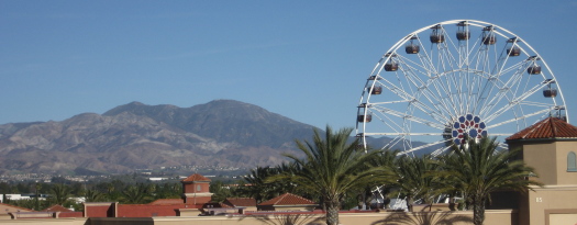
The following day, on my way to lunch at the Irvine Spectrum (7 miles away, and perhaps a 30-degree difference in angle), I went over a bridge and saw Saddleback next to the Ferris wheel. I knew I had to get that shot.
I parked in the west parking structure, then went running around the top floor looking for a spot where I could frame the wheel and the mountains together, and avoid too many light poles, and get above the few cars, and not have to worry that losing my balance would cause me to fall 3 stories to my death. I finally climbed onto one of the support pillars for the light poles in the middle of the deck, where if I fell I’d only fall a few feet.
Here, you can really see the difference between the areas that burned and those that didn’t. Compare this to the third picture in Saddleback Snow, or the second in Ashen Mountains.
Sadly, the best places to take photos from seem to be the middles of freeway bridges and tops of private buildings — in other words, inaccessible.
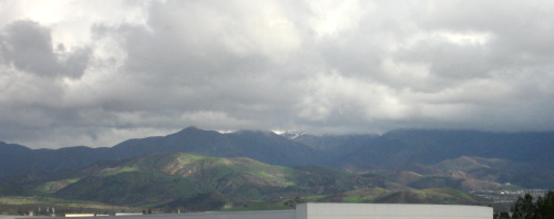
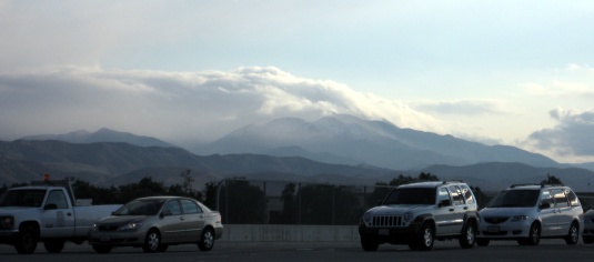
There was a little snow on Mt. Saddleback on Sunday, but not much worth mentioning. Sometime early Tuesday morning, though, a freak storm seems to have hit the mountain… and only the mountain. We certainly didn’t get any rain down here in the flatlands.
At 8:20, the mountains were still shrouded in clouds:
By 9:00, the clouds were starting to burn off, leaving behind a coat of snow, not just on Santiago and Modjeska peaks (still behind clouds), but on the lower peaks to the northwest.
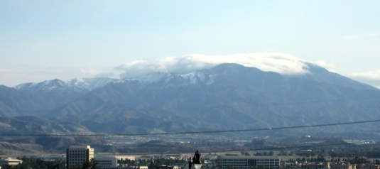
By noon, most of the snow had melted. There’s still some in the shadowed crevices.
UPDATE DECEMBER 19, 2008: This post is getting a lot of traffic today, but it’s from last winter. If you want to see photos from this week’s snow, check out my Snowline photoset on Flickr