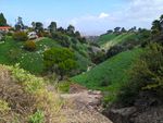
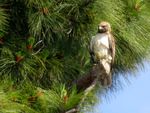
Gorgeous views from the trailhead, and I even saw a hawk just perched in a tree the second time I tried to hike here, but the trail downstream is closed and I couldn’t find the trail upstream on either visit.
Getting There
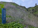
There’s a sign off of Montemalaga Drive across the street from a church. The upstream trail should be right by the sign, but it was too overgrown for me to find. It’s not clear whether you’re allowed to park in the church lot for hiking or not, but there’s plenty of street parking.
The trail itself isn’t on the PVPLC main map, just the reserve boundary. The website links to the Portuguese Bend PDF instead. It’s not on AllTrails as far as I can tell.
PVPLC does link to the trailhead on Google Maps, which shows another connecting trail on the far side of the church. Apparently the downstream end of the trail connects to Via Campesina and the upstream end connects to the Mossbank Trail, which conncets Basswood Ave and Mossbank Drive.