Point Vicente
Park and Vicente Bluffs Reserve (Palos Verdes Peninsula, CA)
★★★★★
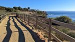
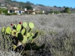
The nature reserve runs along the coastal bluffs. Wide trails run along the tops and through scrub habitat. The trails are fenced, graded, and mostly flat, suitable for an easy stroll and probably wheelchairs. A good place to spot seabirds as well as scrubland birds like white-crowned sparrows. No shade, but plenty of ocean breezes.
On clear days you can easily see all of Catalina Island across the channel to the south, and the Santa Monica Mountains above Malibu, across the bay to the northwest.
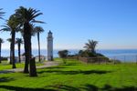
Between the lighthouse grounds and nature reserve there’s a city park with grass, trees, and picnic areas. (The park has shade!) A visitor center features restrooms, drinking water, a few maritime and nature exhibits, and a curated native plants garden, and is sometimes used for event space.

The park isn’t part of the reserve, but a trail with interpretive signs runs along the edge of the cliffs from from the south edge of the park to the north end of the nature reserve, wrapping around several coves that make for interesting views.
I have a Flickr album with more photos from walks over the years.
Nearby
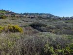
Uphill and across the road, there’s Alta Vicente Reserve which offers slightly wilder hiking with…let’s say a lot more vertical variation.
Getting There
You can drive around the peninsula from either end, and turn into the parking lot from either direction, though the signage isn’t very clear either way.
Heading south from Torrance it’ll be the first right tern past Hawthorne Boulevard and Golden Cove shopping center. And yes, that’s the same Hawthorne Boulevard, so if you prefer driving over the hill instead of around it, you can do that.
Coming from San Pedro, it’ll be past Terranea and Pelican Cove (which has a large rock formation sticking up between the road and the cliffs), and it’ll be a left turn toward the ocean. (This would also mean driving over the landslide, which is its own kind of trip.)
Leaving, you can only turn right, so if you’re heading for Torrance, you’ll need to make a U-turn at Terranea.
More info at Point Vicente.
Located at 31501 Palos Verdes Drive West – Rancho Palos Verdes, CA 90275 US