White Point Nature Preserve

★★★★☆

A wide, flat area of mostly dry grass and some scrub, with a scrubby hill to the left and the ocean to the right. Dirt roads cross the flat area, and clumps of darker green trees are visible on the ocean side of the plain.

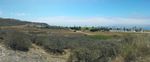
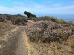
Mostly flat, with hills along the west and north. Views of the ocean and (on a clear day) Catalina Island. Not much shade except for one stand of trees at the foot of the hills, the garden around the visitor center, and the bunkers.

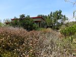
It’s not as geologically interesting as [Forrestal Reserve], and when I went there in August it was mostly dry grass and dry bushes, but there’s wildlife, and there’s a native plants garden around the visitor center that’s watered and maintained, and there’s the ruins if you’re interested in that.

Dirt trail winding past a low bushes, some with pale pink flowers, others with light green leaves. A darker, off-center tree is visible a ways down the trail, with the ocean and a partly-cloudy sky beyond. Cluster of low scrubby bushes with green leaves and light brown flowers. Behind it, a few trees wrapped around a solitary olive-green building. The plants all look like they've actually had access to water, unlike most of the ones in the other photos that have dried out for summer.

Wait, Bunkers? Ruins?

Flat area in front of a hillside with mostly dry grass. A wide concrete structure is built into the hill and flanked with palm trees. A dark opening is visible in the middle of the bunker, with a round concrete awning protecting it from above.During World War II, the land was seized from Japanese-American farmers. The farmers were sent to internment camps, and the land was turned into a military site for coastal defense. During the cold war it became an anti-aircraft missile site. The base was decommissioned in the 1970s, but you can still find concrete foundations and a handful of buildings…and up in the hills, two large concrete bunkers built into a ridge that you can walk right through. Internal doors look like they’ve been sealed, though. (I didn’t think to ask at the visitor center whether it was one of the remaining buildings from the base or whether it had been built later.)

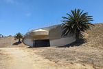
Information boards scattered at points along the trails tell the story, along with the earlier history of the site back to the native Tongva villages and the Spanish ranchos.

Nearby

Looking along a railing outdoors on a sunny day. To the left, the ground drops off steeply. A beach and the ocean are visible below. To the right there are tufts of grass, palm trees, bushes and a paved path. A line of benches and plaque stands runs between the railing and the path.Across the road there’s a regular park that goes right up to the edge of the bluffs. You can look over the railing and see rocky tide pools and Royal Palms State Beach below. The park also has a playground, picnic tables, bathrooms and drinking water.

If you want to make a day of it, you could hike the preserve in the morning, have a picnic lunch at the park, and hit the beach in the afternoon.

Getting there

Follow Western all the way to the coast and then turn left. The road runs past the entrance to the beach parking and a park to the right, and there’s a gate on the left just at the end of the road that leads to a gravel parking lot for the nature preserve. You can also park along the street once you get past the park, or you can pay for beach parking.