Researchers simulated a 70-year mega-drought and came up with ways that California could survive without the economy collapsing, emptying out the state, or even abandoning agriculture. We’d have to change the way we store and distribute water, recycle more wastewater, do groundwater replenishment, prioritize different (and less thirsty) crops, and of course cut down on our water use. It would hurt, and smaller, rural towns would be worse hit than cities (which is already happening — there are places out in Tulare county, for instance, where wells are drying up and homes no longer have running water). But the simulation suggests it could be done — and it’s a good idea to plan for this, just in case, rather than relying on the drought to end in a year or two. Geologic evidence suggests that decades-long droughts used to be the norm, and of course who knows what “normal” is going to be over the next century.

Another article details how Southern Californians have been changing water use this summer: letting lawns die, using more reclaimed water, draining fountains and converting commercial landscaping. The average Los Angeles resident has cut back to 89 gallons per day.

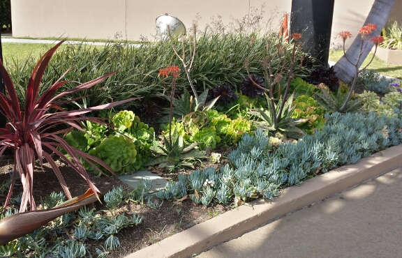
I can’t say I’ve seen much change in my area since I started noticing the occasional lawn replaced with native plants back at the start of the year. Maybe a few more native gardens or scraggly lawns, but not a sea change. Katie does a lot more walking, though, and she’s noticed that a lot of houses just have dirt. Apartments mostly still have lawns, but at least that’s more people per square foot of grass. Unfortunately nobody wants to wash the smears of dog poop off of the sidewalk.

Swimming Pool Under Construction.
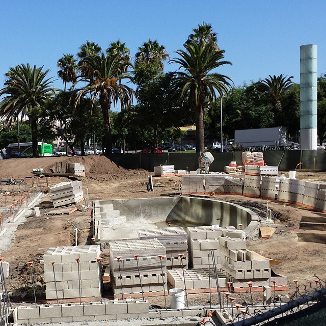
Meanwhile, the office building to hotel conversion next door to my workplace has embarked on what they’re replacing that giant lawn with: a swimming pool. A sign out front proclaims an early 2015 opening. Someone’s optimistic about water for next year.

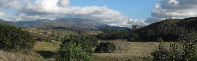
On a related note, the Irvine Company is planning to donate what’s left of the Irvine Ranch to the county as open space. Good!

I’ve lamented the loss of both open space and local farmland over the past twenty years or so as more and more of Orange County has been paved over with houses and shopping malls. Since moving to the South Bay, I’ve seen the potential endgame. “Open space” out here consists of the occasional empty block that’s been set aside, or a hillside that’s too steep to build on conveniently. Palos Verdes has a bit more, but it’s filling in. At least the Portuguese Bend area is likely to stay clear, since the ground isn’t stable enough to build on.

Since speculating idly on replacing roadside and median grass with more drought tolerant landscaping, I’ve started noticing spots around town that have done just that — some of them on my daily commute! An office building here, a mini mall there, an island, or the sidewalk strip in front of a single house. Not a sea change, but a beginning, or at least an experiment.

I’ve also spotted a few more houses that have taken out their lawns in favor of wood chips or rocks and a less-thirsty garden. Maybe it’s the variety, maybe it’s just that the people who’ve put in the effort to convert their lawns have actually, you know, put some effort into it, but they actually look better than a lot of the lawns out there. (As renters, we don’t really have the option of replacing the lawn, but we’re trying to be smarter about our patio and the strip we manage alongside a walkway.)

Spiky shrubs, lavender flowers, agave, and tufts of scrub grass are all common. Some of the roadside strips look like well organized chaparral. Birds of Paradise are common too, but I’m not sure how well they handle low-water conditions.

On the other hand, none of that helps if you keep watering like it’s grass, or use sprinklers that water the street and sidewalk as much as the soil around the plants. Just on my lunchtime walks I’ve found patches of grass where the dirt is always on the verge of becoming mud, and driveways that always seem to have puddles below them. Someone didn’t get the memo.

And then there are the strips of bare dirt that remind me why ground cover of one sort or another is necessary: erosion has left concrete plugs sticking up out of the ground around fence posts, or brick walls leaning out toward the street.

I suppose you could go the route I saw along one street: fill the island with concrete and paint it green. But that’s not only uglier than dirt (literally), it has the critical disadvantage that when it does rain, the water doesn’t even have a chance to sink in. And we desperately need to convert that rain to groundwater instead of flushing it all out to sea.

Landscaping

The city of Los Angeles recently finished replacing all of its streetlights with high-efficiency LED lights. They use less power, last longer, and require less maintenance than even the sodium vapor lights — an all-around win. They also cast a slightly bluish light, eliminating the amber look of sodium. But my first thought was that with all that work, they could have taken the opportunity to combat light pollution. The night sky doesn’t seem any darker than it did when we moved up to this area.

Then I took a good look at these LED street lights near work. The new fixtures actually do aim all the light downward, shielding upward leakage. They’re plenty bright from the ground, but from a few stories up, I couldn’t tell which lights were on without looking below them to see whether there was a pool of light on the ground.

So if the streetlights really are leaking less light into the sky, why is it still so hard to see stars to the north? Seriously, I can see Orion clearly most nights, but the Big Dipper is practically impossible to pick out.

  • It was a city project, not a county one. There are plenty of other cities in the area that either haven’t been converting their lights, or have only converted a few.
  • They didn’t actually convert all the streetlights in town, just the standard, boring ones (141,089 of them). Phase 2 is converting decorative street lights.
  • There are lots of other lamps that leak light upward: Parking lots, building lights, private roads. LAX is to the north, and there’s a reason for the phrase “lit up light a landing strip.” There’s also a park nearby with a baseball field; those lights drown out quite a bit when they’re on.
  • The ongoing drought has caused smog levels to climb, making the skies hazier.

Rain lit up by a car headlight.Speaking of the drought, I found myself wondering: How much water would we save if the city did a similar project to replace all the grass along street medians, parking lot boundaries, etc. with drought tolerant native plants? A home lawn at least has a potential use as a gathering place, or a play area. But a little strip of lawn six feet across? What’s the point?

And what do they do with medians out in the high desert, anyway? I remember driving out to Joshua Tree once and noticing in one of the towns along the way that all the houses were built on a standard suburban lot plan with space for a lawn, but that they used it for rock gardens, or native plants, or just left it empty. But I can’t remember what they put along the sides and middles of city streets.

And that gets me to the other article: It was a summary of a study on the vulnerability to climate change in various parts of the region. Most of LA will handle a rise in sea level fine, except for the beaches, Marina del Rey, and San Pedro…but depending on how the climate changes, most of LA would be vulnerable to severe flooding.

In any given decade in California, you can expect at least one drought and at least one winter of heavy rains and flooding. And sometimes those floods can be spectacular. A flash flood in 1825 changed the course of the Los Angeles River (it used to flow into what’s now Marina del Rey). And then there’s the Great Flood of 1862, which covered huge swathes of California and Oregon with water, including all the lowlands of what are now Los Angeles and and Orange County.

So in addition to planning for drought, the region also plans for the occasional flood — unfortunately, by trying to channel all that water out of the way as quickly as possible, because, as the study pointed out, more than 80% of the ground in the area is covered with impermeable surfaces — you know, asphalt, concrete, buildings, etc.

They do have spreading ponds to replenish groundwater from at least part of the storm drain system, but a lot of that water just goes straight into the ocean, and in heavy rains, the ponds get overwhelmed anyway.

It just seems like there ought to be a better way to capture the rain we do get.

I started writing this on an airplane about to take off. In the time between my outbound flight and return trip, United took advantage of new FCC rules to draft a new policy allowing passengers to continue using (if I can remember the phrasing) “lightweight personal electronic devices set in non-transmit mode.”

I did have to stop as a matter of practicality during the takeoff itself, and being in a window seat I spent a lot of the next few minutes staring out the window.

Something I found interesting on the way up is how similar open space and water look at night from far enough up when you’re near a city, especially if the city just stops…especially at a natural boundary like a range of hills. In both cases you have a brightly lit region next to completely dark area. It’s only when you can identify patterns like docks, or roads through the empty space, or occasional lighted areas (though they could be boats) that you can really tell.

If you’re low enough, you can sometimes see the reflections of lights in the water. That made for an interesting illusion on the flight in. I’m not sure which bridge it was across the San Francisco bay, but it’s lit by regularly spaced white lights underneath the roadway. For some reason it looked like the lights were moving along the bridge as I flew past it, like the pulses inĀ  a Mac progress bar.

Something else that struck me: most areas along the California coast, seen at night, appear as darkness with islands of light. Greater Los Angeles is light with islands of darkness.

No wonder I can hardly see any stars these days.

Green hills roll back to a half-moon shaped bay in the distance, an immense round rock near the shoreline. The rock is taller than the trio of smokestacks nearby. More hills are visible on the far side of the bay, and the hazy gray-white-blue sky above the brighter blue of the ocean.

Morro Bay lies along the central California Coast near San Luis Obispo, and is known for two major landmarks: Morro Rock, a large volcanic dome right near the shoreline, and a power plant with three very tall smokestacks.

Some miles north, Highway 46 cuts through the coastal mountains from Cambria to Paso Robles, revealing cattle ranches, wineries, and empty hills. There’s one spot along the road where the hills part, revealing a perfect view of the bay and the rock. Better yet, there’s a turnout, making it easy to stop and look.

The first time I drove this way, it was gray and overcast, and might actually have been raining. A year later I took the same drive again on an sunny day, unable to remember how far along the turnout was but watching for it the whole way. The result: this shot.

The curves of the dome, the bay, the rolling hills and the patch of heavier vegetation all fit in with this week’s theme.

Photo Challenge (WordPress): Curves