I spotted workers trimming the palm trees at lunch today. In Irvine, that involves a bucket crane and a chainsaw, with a couple of guys on the ground to pick up the fallen fronds and pile them off to the side.

Trimming the palm fronds, mainland style

This contrasted heavily in my mind with the tree trimmers I saw in Hawaii, where a guy would shimmy up a palm tree with a rope and a machete, then hack away.

Trimming the palm fronds, Hawaii style.

I saw them rotating the crane to move the guy to a new tree, so I’m sure the mainland style trimming gets done faster than the island style… but then, we’re always in such a hurry here. Too bad we can’t do our landscaping on island time.

The Moon and Venus behind a tree (Nov. 5, 2005 @ 5:09pm PST)

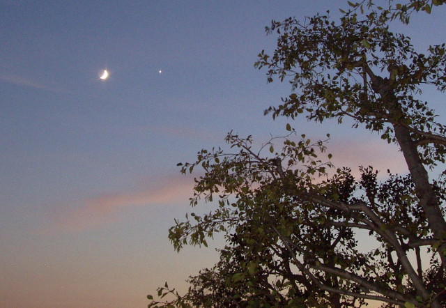
This view of the Moon and Venus was taken from our apartment balcony earlier this evening.

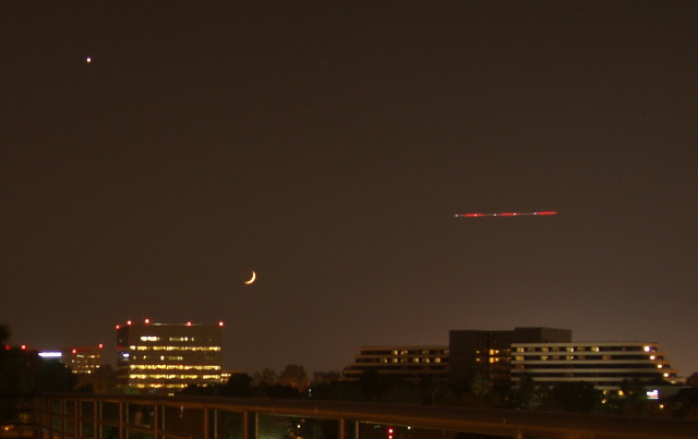
I also took a picture yesterday, from the top of a parking structure near John Wayne Airport (we went to a show at UCI later that evening.) You can see the red trail an airplane left as it crossed the frame:

The Moon and Venus above a cityscape (Nov. 4, 2005 @ 6:01pm PST)

Having seen that pairing last night, I knew I had to be ready to catch it today! I figured the Moon would be a lot closer, but I hadn’t expected it to actually pass Venus tonight. It really gives you an idea of how far the Moon moves in 24 hours. (or, in this case, roughly 23 hours, since yesterday’s picture was taken at 6:00 and today’s was taken at 5:10).

To be honest, I wasn’t actually certain it was Venus. It was my first thought, because of the brightness and the color, but I kept thinking it was too far from the sun. I kept trying to convince myself it was Jupiter or maybe Saturn (it wasn’t red enough for Mars, and besides, I’d seen Mars on the other side of the sky the night before). When I looked it up and realized it was Venus, I started remembering my days in high school when I would walk to school for a 7:00am “zero period” class. In winter it would sometimes be just dark enough when I left to see the planets and the brightest stars. I would keep my eye on Venus as the sky brightened, trying to see how late I could still see it by knowing exactly where to look.

Pickle-and-onion Catamaran

You know how some restaurants always give you a pickle with their sandwiches? Well, at Ruby’s today I finished, picked up the toothpick flag that had been stuck in the hamburger, turned the pickle over and planted the flag, declaring it to be a boat. Katie immediately took her pickle and a leftover onion slice and turned it into an outrigger. A bit more manipulation, plus a napkin for a sail, and it became a catamaran.

Our waiter did a double-take when he picked up the plate, then set it down on the counter. We like to think it was so the other waiters could see it.

I love carving jack-o-lanterns. These days, though, I don’t have much motivation to do one unless there’s a prize involved. So when I saw that someone on Puzzle Pirates was holding a contest for piratey-themed pumpkin carving, I jumped on it. This is my rendition of the navigation puzzle from the game, and my first-ever attempt at a projector pumpkin. I think it looks okay.

the navigation puzzle has looked better

glowy stars and projected arrrrrs

The lit picture is pretty dark, but it had to be or the “Arrr!” on the wall wouldn’t show up.

Suggestions for next year, or even out-of-season carvings for this year, are being taken……

Here’s our first view of the island of Hawai‘i, as our plane approached on Sunday morning, April 3. Snow-capped Mauna Kea is rising out of the clouds, with Mauna Loa behind it.

View of Mauna Kea from the plane

A week later, we spent Sunday evening waiting for our flight out of Kona Airport. (After a disastrous experience at LAX in which we arrived 2 hours ahead and got to the gate with maybe 15 minutes to spare, we showed up early for the flight home. But Kona’s much smaller and better organized, so it took us maybe 15 minutes to check in. There wasn’t even a line to go through security!)

Kona airport at night

I hope you’ve enjoyed this series on our Hawaiian vacation. I’m sorry it took so long to finish it, but hey, I managed (just barely) to beat the 6-month marker!

Flashback to April and Hawaii. On the day we drove to Kilauea we stopped at various places along the way. And since it’s a nearly-100-mile drive from Kailua, there was a lot to see.

We never made it down to South Point (the southernmost tip of the island), partly because of time and partly because—believe it or not—our car rental contract forbid us to drive on the 12-mile road out to the point! Supposedly it’s poorly maintained—or it used to be, and the policy hasn’t kept up—and they don’t want the wear and tear on cars that aren’t designed for it. As I recall, rental trucks and SUVs don’t have the restriction. This was the closest we ever came to it, and you can only barely see it way off in the distance.

Coastline with coves and points

If you look at the end of the spray near the visible point, then go straight up toward the horizon, you’ll notice that the sky-sea line dips downward slightly and there’s a faint darker patch of sky. As far as we could tell, that’s the promontory heading out toward South Point. Even then, we weren’t quite sure. Update: It’s not. I checked the map when I finally uploaded these images to Flickr, and the highway doesn’t get close to the ocean on the west side. It’s a viewpoint near Haleokane, east of Naalehu and east of the turnoff to South Point Road. We’d already passed it!

Continue reading