In early August, we went up to Santa Monica to visit my brother and his colleagues as they returned to Florida from Wikimania 2007 in Taipei… with a 10-hour layover at LAX.

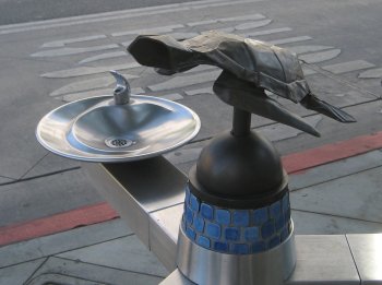
We carpooled with my parents, and arrived while the group was still stuck in customs. So we wandered around the Santa Monica Promenade and pier for a bit. Not surprisingly, there were some strange things about, like this turtle-themed drinking fountain.

Turtle and drinking fountain

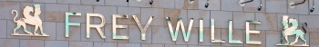
Then there was this sign, on the Johannes van Tilburg Building, which I couldn’t quite decide how to take. “Free Will?” “Free Willy?”

Frey Wille

The most disturbing was probably this mash-up of two movies on one of the many theaters on the promenade:

Marquee: Knocked Up, Bratz

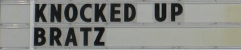
Is the American public ready for that film?

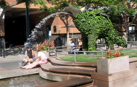
There are topiaries sculpted into the forms of dinosaurs scattered along the promenade. This stegosaurus came out the best:

Stegosaurus topiary

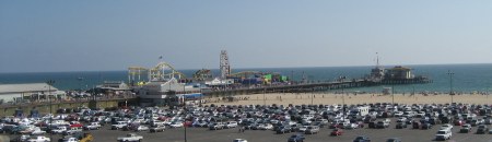
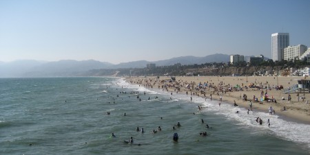
As I mentioned, we did wander out to the Santa Monica Pier after a bit. Nothing terribly odd, just a couple of photos to set the scene:

The pier viewed from the cliffs

Santa Monica beach and cliffs, seen from the end of the pier

Flashback to April and Hawaii. On the day we drove to Kilauea we stopped at various places along the way. And since it’s a nearly-100-mile drive from Kailua, there was a lot to see.

We never made it down to South Point (the southernmost tip of the island), partly because of time and partly because—believe it or not—our car rental contract forbid us to drive on the 12-mile road out to the point! Supposedly it’s poorly maintained—or it used to be, and the policy hasn’t kept up—and they don’t want the wear and tear on cars that aren’t designed for it. As I recall, rental trucks and SUVs don’t have the restriction. This was the closest we ever came to it, and you can only barely see it way off in the distance.

Coastline with coves and points

If you look at the end of the spray near the visible point, then go straight up toward the horizon, you’ll notice that the sky-sea line dips downward slightly and there’s a faint darker patch of sky. As far as we could tell, that’s the promontory heading out toward South Point. Even then, we weren’t quite sure. Update: It’s not. I checked the map when I finally uploaded these images to Flickr, and the highway doesn’t get close to the ocean on the west side. It’s a viewpoint near Haleokane, east of Naalehu and east of the turnoff to South Point Road. We’d already passed it!

Continue reading

We didn’t get to see much of the Hilo side of the island. Our last day there, we checked out of the hotel and just started driving, figuring we’d just see how far we could get before turning back to make our flight. We did actually make it to Hilo itself—just in time to turn around. (It was a Sunday anyway, and supposedly there isn’t much open in Hilo on Sundays.)

When we first crossed through Waimea to Hamakua, we took a side trip north to the lookout for Waipio Valley. The valley itself is unreachable without 4-wheel drive (the road has a 25% grade), but the view from the lookout was incredible:

Waipio Lookout

Continue reading

It’s taking me longer than I thought to post all these Hawaii photos. North of Kona there are miles of old lava flows, the most recent of which were in 1801 (from Hualalai, the volcano above Kailua) and 1859 (from Mauna Loa, the second-higest peak on the island). Because the island is right in the middle of the trade winds, and has sizable mountains in the middle, the clouds all bunch up on the eastern side of the island, dropping several hundred inches of rain a year before stopping—rather abruptly—halfway across the island. The west side of the island, especially in North Kona and Kohala, gets closer to 10 inches of rain a year. That’s not far off, climate-wise, from Southern California. It also means that there’s not enough plants to break up a lava field in only 200 years, and large chunks of the coast look like this:

A‘a lava flow in Kohala (with coral graffiti!)
That’s not dirt, that’s rock! You may be wondering about the white bits. They’re a sort of temporary graffiti. All through this area, people have dragged out bits of coral to spell out messages ranging from “Hi Mom” and “Aloha Dolly” to “In Memory Of…” For some reason it’s almost universally good-natured. Katie’s got some interesting pictures. that we’ll be posting later.

Here’s a view of the coast itself. Continue reading