One of the nice things about a lunar eclipse is how accessible it is. You don’t need binoculars or a telescope (though it helps). You don’t need protective gear. You can see it from a city street with lights on. You don’t need to be in exactly the right spot to see it, since the viewing area is measured in multiple continents rather than a narrow track. And since it lasts longer than a solar eclipse, if the clouds roll in moments before totality (which they did), you can wait a few minutes and you might still be able to see something!

The last time a lunar eclipse was visible in our area, I woke up at ridiculous-o’clock in the morning and went out to watch, first across the street, then trying to find a clear view in the west before sunrise and moonset drowned everything out.

This time I just walked out into the front yard.

Lunar eclipse mosaic
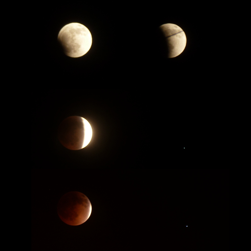
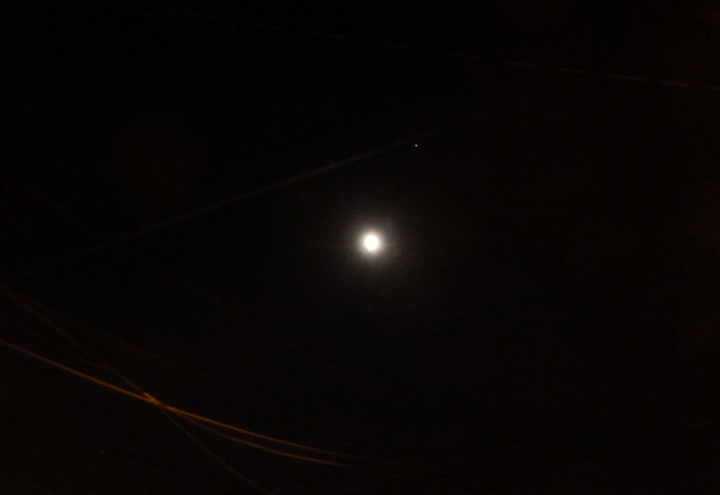
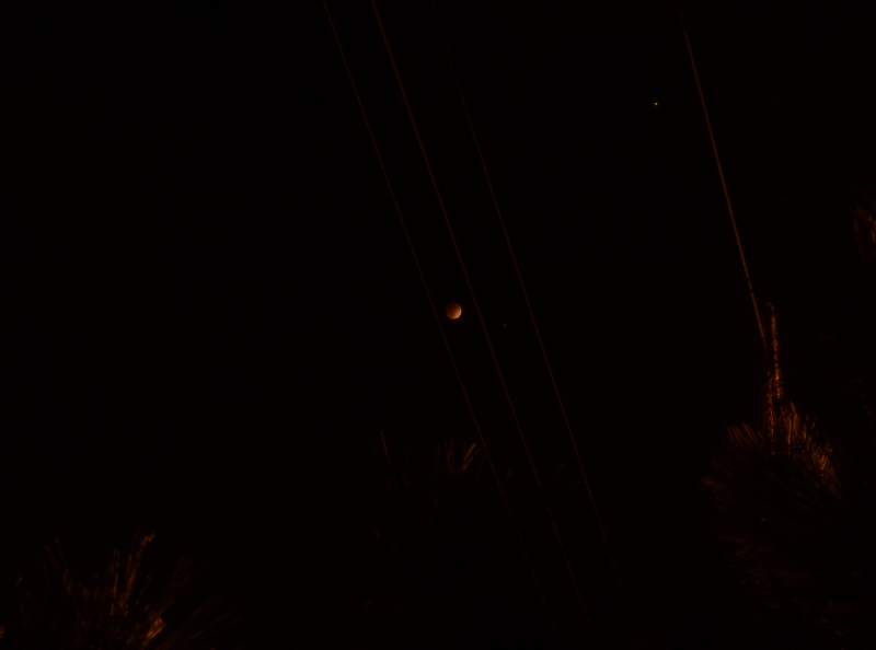
Four stages of the eclipse. I’m not sure what the star next to the moon is. As Sam points out, the star is Spica. The phone line bisecting the second view looked interesting, so I went with that rather than an unobstructed shot. In retrospect, I should have tried to frame it to look like the Death Star trench.

My son is almost 3 1/2 now, just old enough to appreciate this sort of thing, so I spent the last few days talking it up. We went out to look at the full moon early in the evening. We read a kids’ book on stargazing that he likes. I showed him pictures of what to expect, and diagrams showing how an eclipse happens. He’s been wanting to play with a tent ever since I mentioned the phrase “camping stuff” a few days ago, so we found the tent in the garage and set it up in the front yard. He had as much fun playing in the tent as he did watching the earth’s shadow move across the moon.

Katie stayed inside most of the time and came out a few times to check on progress.

At one point, an airplane flew across the sky leaving a sharp, bright contrail just next to Mars.

Moon Mars Power Lines and Contrail

We were all out just before totality around midnight…when a cloud started forming right in front of the moon. Mars, not too far away in the sky, was perfectly clear, but the moon got blurrier, and blurrier, until the razor-sharp sliver of a few minutes before was a blob of white. It reminded me of the time we saw about that much of an eclipse in San Simeon on the way up to (coincidentally) WonderCon when it was in San Francisco.

Fortunately the cloud started breaking up again after a few minutes, and all we had to do was hold up our hands to block the streetlight across the street and we had a clear view of the fully eclipsed moon. (We could see it without blocking the light, but it was a lot clearer without the competition.)

I should probably mention that while the pictures here look red, it looked brown to the naked eye. Maybe it was because the streetlight kept our eyes from adapting to the dark. Maybe the camera is more sensitive to red light. Katie remarked that without the sunlight shining on it, it really does look like what it is: a big ball of rock.

Eclipse Lineup

After a few minutes we went back inside. Neither of us wanted to stay up until two to watch the same thing in reverse…or manage an increasingly tired and distracted three-year-old while doing so.

My first hint that something was wrong this morning was the extremely yellow sunlight coming in around the blinds as I got ready for breakfast, the color you expect right at sunrise or sunset, not after the sun’s already up. Once I walked outside it was clear there was a fire somewhere in the area, and as I walked around the building I could see smoke filling half the sky.

It only filled half the sky, though. The smoke rose from the fire near Glendora, at the base of the San Gabriel Mountains northeast of Los Angeles, and drifted south to Orange County before winds blew it west across Long Beach, San Pedro, and the Palos Verdes peninsula.

Off to the west of the plume, the skies remained clear. Clearer than usual, in fact, because high winds had blown all the smog out to sea over the last few days. To the north and west, the sky was a gorgeous blue, the mountains and distant city skyline crystal clear. (If you view the larger image on Flickr, you can spot downtown LA right next to the first telephone pole on the left.) Smoke in the southeast turned the sun orange, bathing the area in light more suited to the golden hour.

A few miles north and a bit later, this view looking south shows the clear blue northwestern sky reflected in the building, the smoky southern sky behind it, and another building lit orange by the smoky sunlight.

Looking up at a whole bunch of old-fashioned lampposts clustered together, ridged columns and lit globes seen against a dark blue sky.

Urban Light at LACMA is a large square filled with over 200 lamp posts that the artist collected from various locations over several years, spaced wide enough to walk through comfortably. It’s like being in a forest of lamp posts — perfect for this week’s challenge.

The funny thing is, I wasn’t even planning on going there. We went to see the La Brea Tar Pits and Page Museum at the other end of the park. Oil has been seeping out of the ground for thousands of years, trapping animals and preserving their bones in an incredible collection of ice age fossils. But the parking lot on that side of the park was full, so we parked in the LACMA structure at the other end.

Photo challenge (WordPress): Light Continue reading

Halo Towers

I developed an interest in sun halos a while back. Bright rings and arcs can appear in the sky when ice crystals are lined up just right with your viewpoint, much as a rainbow forms when water droplets are lined up just right.

You see a lot more of them, and especially the most spectacular ones, in colder climates where ice crystals form more often. But I still see several circular halos and sundogs each year even in Southern California, particularly when there’s a thin layer of cirrus clouds. The ice crystals only need to be in a line of sight, not near the ground.

The arc at the top of this photo, looking like it’s bridging the two buildings, isn’t a rainbow — the colors are wrong and too pale, and it’s in the same direction as the sun (which is behind the building on the left). I think it’s a 22-degree circular halo, but I’m not certain. It looks a little bit too shallow, so it could be a tangent arc, but I’m not sure the sun was quite high enough for it to point downward from the tangent instead of upward.

Here are some other sun halo photos I’ve posted on this blog in the past.

Los Angeles skyline in shadow, foreground in light. Los Angeles skyline in light, foreground in shadow.

I went out for a brief walk Thursday afternoon (sometimes you just need fresh air). It had been raining, but had stopped, and the sun had broken through the clouds. Something made me go up to the top of the nearby parking structure where I could see downtown Los Angeles. It turned out to still be completely in shadow, as the gloom stretched inland. But it made for a great contrast with the sunlit hotel in the foreground.

The next day, another of intermittent rain and sun, I glanced out my office window shortly before sunset and took another short walk, this time straight to the parking structure for a better view of the mountains. The sun was sinking past open patches in the cloud layer, and I realized it was only a matter of time before it lit up the city in the distance.

Sure enough, a few minutes later, downtown Los Angeles was lit up by the sunset, and while I was at the wrong angle to see the towers turn completely orange as I did once on the train nearly three years ago, I was able to line up the same angle as the photo from the previous day…because this time the nearby hotel was the building in shadow.

I’ve found my lunchtime patterns fossilizing. Mostly, there aren’t a whole lot of places to eat within walking distance that aren’t hotel restaurants and therefore expensive, and parking is such a chore that it’s not worth driving anywhere. So I end up going to two fast food places and two cafes, over and over again.

The other day, I started to walk to Subway, and realized I just couldn’t bring myself to eat there again. So I did something I’d never done: I kept walking. As it turns out there wasn’t anyplace to eat past it, just two more hotels (neither of which advertised a restaurant) and an abandoned office building. From there I walked along Sepulveda until I reached In-N-Out.

Along the way, though, I spotted some interesting items, like this old warehouse:

Continue reading

It's gloomy. The sky and sea are almost the same shade of gray. Looking along a steep cliffside toward a rock outcropping. It's high, maybe ten times as high as the low building perched on top of it, and grooves show dozens of layers stacked from the sea below to a bit below the top.

The Palos Verdes peninsula sits at the southwest corner of Los Angeles. Parts of it are built up in old, grid-style suburbs. Other parts are of the more modern, winding type. And still other parts remain open space, due in part to the unstable geology of the area. Parts of Portuguese Bend are sliding toward the ocean, requiring frequent repairs of the main road along the coast. Way back in 1929, a housing development began sliding into the ocean. Abandoned now, the area remaining above land is known as the sunken city.

Adjacent to those ruins is Point Fermin Park, an ordinary city park that sits atop the cliffs. The Point Fermin Lighthouse (previously featured here) looks over the sea, and a fenced walkway runs along the length of the cliffs.

Looking out here, you can see the layers of rock, and understand how parts of the point could just slide away. The warning signs on the fence don’t surprise me, but I have to wonder just who would want to climb out there.

Photo challenge (WordPress): Layers